- Domů

- Digitální fotografie
- Nicolas de Fer
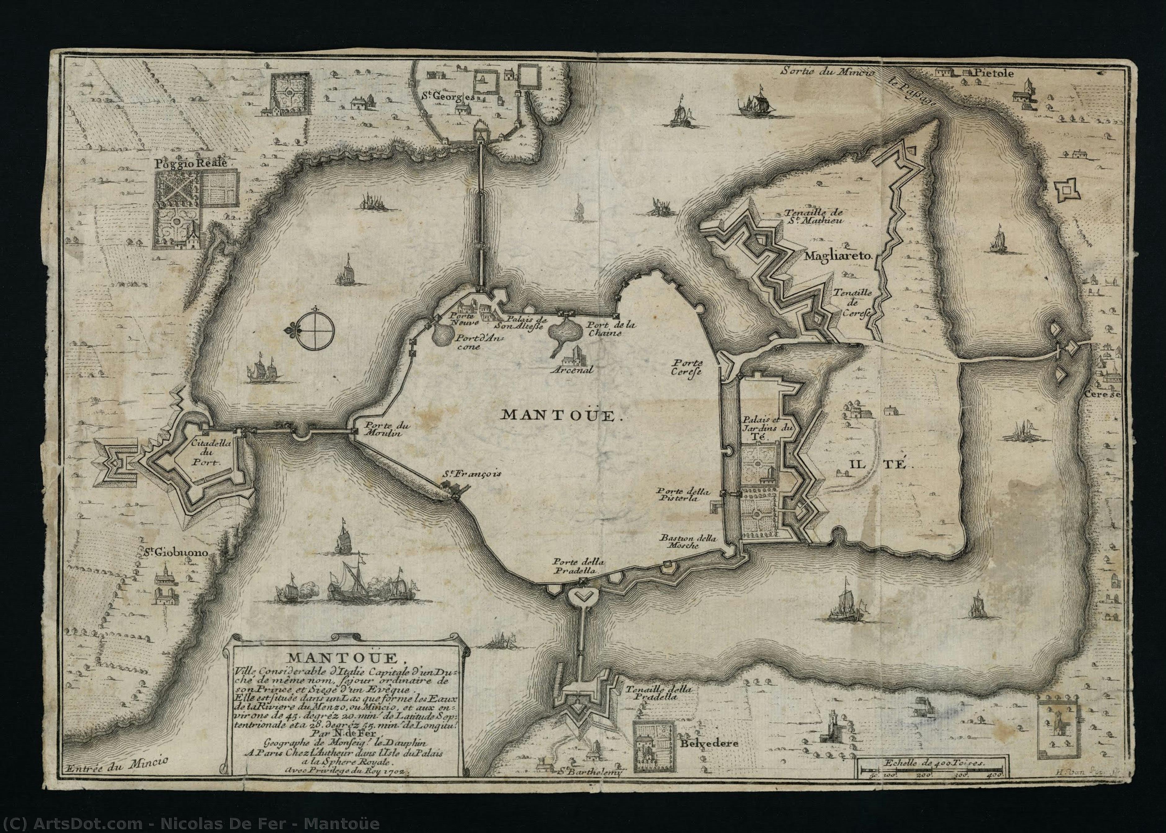
- Mantoüe
 Sdílet
Mantoüe

Koupě vysoce rozlišeného, vylepšeného digitálního obrazu, který je mnohem kvalitnější než online náhled.
Každý soubor je pečlivě připraven našimi odborníky pomocí pokročilých nástrojů a expertní manuální retuše. Zajišťujeme, aby každý obraz disponoval výjimečnou ostrostí, přesnou barevnou věrností a jemnými detaily.
Finální soubor vám bude do 72 hodin zaslán e-mailem, optimalizovaný pro okamžité použití v profesionálním, redakčním i tiskovém prostředí. Nabízíme stejnou kvalitu, které důvěřují špičková designová studia, nakladatelství i galerie.
Digitální obrazy
Stáhněte si soubor ve vysokém rozlišení pro osobní prohlížení, tisk a kreativní projekty.
Součást každé objednávky digitálního obrazu
Profesionální digitální doručení, zaručeno.
Když si vyberete OriginalUniqueArt.com, nezískáváte pouze obrázek – získáváte digitální umělecké dílo s profesionálně vylepšenými detaily, zpracované s precizností a podpořené zárukou za spokojenost. Zde je vše, co vaše objednávka automaticky obsahuje:

Rychlé doručení e-mailem
Váš digitální obraz ve vysokém rozlišení vám bude zaslán e-mailem do 72 hodin od objednávky – připraven k okamžitému použití.

Digitální soubor s využitím AI
Vaše umělecké dílo je profesionálně optimalizováno pomocí pokročilých nástrojů umělé inteligence a manuální úpravy, což zajišťuje maximální úroveň detailu, ostrosti a přesnosti barev.

Bezplatné doživotní znovuodeslání
Soubor jste omylem smazali nebo ztratili? Žádný problém – kdykoliv vám ho znovu zašleme zcela zdarma.

Bez poplatků za dovoz – navždy
Užijte si své umělecké dílo okamžitě bez celních poplatků, daní nebo nákladů na dopravu – digitální stažení je vždy bez daňových povinností.

Záruka přesnosti barev
Pomocí profesionálních nástrojů a správy barev zajišťujeme, aby váš digitální obraz odrážel původní barvy co nejvěrněji.

60denní záruka spokojenosti
Pokud nebudete s digitální fotografií spokojeni, provedeme její revizi nebo vám vrátíme 100% během 60 dnů – bez jakýchkoliv dotazů.

100% záruka vrácení peněz
Nespokojeni? Získejte plnou částku zpět do 60 dní od přijetí vašeho digitálního souboru – bez jakýchkoliv dotazů.

Slevy při hromadných objednávkách
Koupěte si 3 obrazy, ušetřete 10% - Koupěte si 5, ušetřete 15% - Koupěte si 10+, ušetřete 20%. Ideální pro kreativní projekty, galerie a agentury.
Popis sběratelského kusu
Biografie umělce
The Cartographic Artistry of Nicolas de Fer
Nicolas de Fer, born in Paris in 1646, emerged from a family already steeped in the world of mapmaking. His father, Antoine de Fer, possessed a thriving cartographic business, and it was within this environment that young Nicolas’s fascination with geography and artistry began to blossom. Apprenticed at the tender age of twelve to the Parisian engraver Louis Spirinx, he honed his technical skills, laying the foundation for a career that would see him become one of France's most prolific mapmakers of the 17th century. However, de Fer’s path wasn’t simply about inheriting a trade; it was about transforming it into something uniquely his own—a blend of artistic flair and commercial ambition.
A Family Legacy and Rise to Prominence
The early years following his father's death in 1673 saw Nicolas assisting his mother, Genevieve de Fer, in managing the family firm. It wasn’t until 1687 that he assumed full control, a turning point that marked a significant shift in the business’s trajectory. While Antoine had focused on maintaining established routes and clientele, Nicolas possessed an entrepreneurial spirit, driving production and expanding the range of available maps. He quickly recognized the growing demand for visually appealing cartography, understanding that maps were not merely tools for navigation but also objects of decorative beauty. This insight would become central to his success.
The Aesthetic Over Accuracy: A Baroque Cartographic Style
De Fer’s work is often characterized by a prioritization of quantity over absolute geographical precision. While he produced hundreds of maps and atlases, they frequently contained errors—a consequence of relying on existing sources rather than conducting original surveys. This wasn't necessarily a flaw in his approach; it reflected the artistic sensibilities of the Baroque period, where ornate detail and aesthetic appeal were highly valued. His maps are lavishly decorated with elaborate cartouches, allegorical figures, and vignettes depicting scenes from around the world. L’Atlas Curieux, one of his most celebrated works, exemplifies this style—a testament to the decorative arts that flourished during his time. The detailed depictions of cities, churches, palaces, and gardens were more about conveying a sense of place and wonder than providing precise navigational information.
Royal Patronage and Lasting Influence
De Fer’s reputation for producing beautiful and commercially successful maps eventually led to royal recognition. He was appointed official geographer to both King Louis XIV of France and King Philip V of Spain, a testament to the prestige his work had attained. This patronage further solidified his position within the cartographic community and allowed him to expand his business even further. After his death in 1720, the firm passed into the capable hands of his sons-in-law, Guillaume Danet and Jacques-Francois Benard, who continued to produce maps under the de Fer name for several decades. His legacy extended beyond his own lifetime, influencing a generation of cartographers and solidifying the role of mapmaking as both a scientific endeavor and an artistic pursuit.
A Lasting Impression on Cartographic History
Nicolas de Fer’s contribution to cartography lies not in groundbreaking discoveries or unparalleled accuracy but in his ability to popularize maps and transform them into desirable objects. He understood the power of visual storytelling, using elaborate decoration and detailed illustrations to captivate audiences and convey a sense of global awareness. While modern scholars may critique the geographical inaccuracies present in his work, it’s important to remember that de Fer operated within a specific historical context—a time when artistic expression was often prioritized over scientific precision. His maps remain valuable today not as navigational tools but as fascinating artifacts of the Baroque period, offering insights into the cultural values and aesthetic sensibilities of 17th-century Europe. His work serves as a reminder that maps are not simply representations of the world; they are also reflections of the societies that create them.

Nicolas de Fer
1646 - 1720 , France
Stručné informace
- Artistic Movement Or Style: Baroque
- Artists Or Movements Influenced By This Artist:
- Nicolaus Copernicus
- Giovanni Cassini
- Artists Who Influenced This Artist: ['Louis Spirinx']
- Date Of Birth: France, 1646
- Date Of Death: 1720
- Full Name: Nicolas de Fer
- Nationality: French
- Notable Artworks:
- Mantoüe
- Petit et Nouveau Atlas
- Place Of Birth: France